(An article about the merits of a streetcar to Fremont as a complement to light rail to Ballard was recently posted on Seattle Transit Blog, and I wanted to share it in addition to/as an alternative to my own thoughts below. Find it here.)
Before attending this week's Sound Transit/City of Seattle joint open house on high capacity transit to Ballard, I hadn't thought much about the route it might take to get there. I knew I supported it, and given the failings of the Downtown-to-Ballard Rapid Ride line, it was clear to me that it would need to be grade separated, but beyond that I was fairly unconcerned with the specific route it might take to get from A to B. There was a great interactive exhibit at the event that got me actually thinking more critically about this, and I've realized that it's actually a fairly difficult question to answer.
So let's take a look.
The exhibit was actually slightly different from the image below (this one is just more clear), but they used the same map and asked that you draw the path you'd like high capacity transit to take from Ballard to Downtown. This one, by comparison, asked people to put a green sticker where a frequent trip they take starts, and a red sticker where it ends. As you can see, downtown is by far the most popular destination, at least among those in attendance:

Trip start/finish map - green is start, red is end; image from Ballard News-Tribune.
The routes people drew on the other map included 1) following 15th Ave NW to Elliott Ave then downtown, 2) traveling through Fremont then down Westlake to get downtown, and 3) everything in between.
The key concern for me (and one that seemed to be overlooked by most open house attendees) was that Ballard, Fremont, and Queen Anne all have very similar current populations and population projections over the next few decades--serving one or two of these neighborhoods with light rail while failing to serve any of the others would be unjustifiable.
Most people seemed to prefer a straight path along 15th Ave NW unfortunately, which is the Interbay "neighborhood," if you could even call it that, which has very little population and no plans for growth according to city estimates. Hopefully this just reflected the fact that many probably think an at-grade streetcar alignment is likely, and this would be the path of least resistance. I suspect many of those who supported this alignment would change their minds if they were told that a subway was the most likely option (here's hoping), making traffic and the paths of existing roads irrelevant to subway route considerations.
Working from the assumption that a line would need to serve each of these neighborhoods, drawing a single route to cover all three becomes pretty difficult. In the time I had to think about it at the open house, I ultimately went with the path below:
My first idea for a subway route, which I've since disavowed and am slightly embarrassed to have ever considered.
As you can see, the route is very indirect, traveling through the center of Queen Anne, northwest to Ballard (under Ship Canal), then looping back along Market, 8th Ave NW, and Leary to Fremont. I imagined one station at each of these neighborhoods plus maybe one in Belltown and another around Mercer St. and Queen Anne Ave (more than this many stations seems unlikely, given that even Capitol Hill only got one station).
At the time I liked this route because it allowed for an extension of the line to Stone Way, up to 45th St., then east all the way to the station that's planned at 45th and Brooklyn in the University District, all without transfers. Admittedly, I have a strong personal bias against transfers, and much of that is due to the relatively low frequency of most Seattle buses. A 10-minute-or-less light rail headway would make transfers much more bearable. To mollify the Fremont travelers I thought perhaps there could be some kind of dedicated line, either bus or streetcar, between the Queen Anne and Fremont stations. In retrospect I came to the conclusion that this is a mess and have since discarded this idea.
Seattle Subway, the group I think was primarily responsible for getting the planning for this line pushed onto a faster timeline, has another vision:

Cropped from Seattle Subway image.
I appreciate the ambition of this proposal, but not the actual outcome. For one, if these were both subways the cost would be prohibitive for a single ballot measure with other parts of Seattle wanting their part of the action. I could get over that though. More importantly, the two alignments seem to be along 15th Ave NW through Interbay to Ballard, and along Westlake Ave to Fremont. I don't see many prospects for significant development along either of those corridors (nor do they, it would seem, for Westlake--they don't put a station along any part of it). I'm pretty sure this is just a concept on Seattle Subway's part, so I don't want to give the impression that this is their preferred solution or that they should be criticized for it. It's just one possibility for the purpose of illustration.
There might be a case to make for two separate lines to Ballard and Fremont, but I don't think it's a strong one on the merits and I think it'd be nearly impossible politically unless we were doing another line to West Seattle at the same time. Two lines for northwest Seattle while West Seattle remains stuck with Rapid Ride probably would not go over well.
Assuming we can only afford one subway line to the area in this time frame, I don't see much harm in detouring a bit from east to west to capture the largest population centers, and I do like the idea of including South Lake Union. SLU is already served by the streetcar, and a light rail station would make it largely obsolete, but ultimately this region is going to be a big part of the city both residentially and commercially and people will need/want to get to it without having to travel downtown, leave the station, and wait for a streetcar to take them the last mile. The streetcar is a local transportation solution whereas light rail is more regional--currently there are no great regional connections to or from South Lake Union.
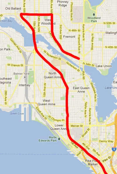
Unfortunately, with one line you'd have a very difficult time including stations in Belltown, SLU, and Lower Queen Anne. I'm going to illustrate a possible route in which Belltown is bypassed in favor of SLU, but I realize that that's a debate worth having in detail at some point. With that in mind, here's my current thinking on the best route for light rail to Ballard:

Red line represents subway route, black circles represent station locations.
First, I'm no transit engineer so I have no idea what kind of turning radius these train cars can handle, but I tried to give the route fairly smooth turns--maybe they need to be even less acute, maybe not. Also, this is clearly not the most direct route to Ballard, but the benefits of capturing additional ridership along the way far outweigh the cost of several extra minutes' travel--remember, there's no traffic congestion underground. Beyond that, I'll break things down station by station:
- South Lake Union: I chose the Thomas & Westlake location mostly for the sake of visibility. Thomas & Terry might actually be a little more functional due to the connection to the northbound SLU trolley, but I think locating on the arterial where more people are walking trumps that concern. It's also a bit easier to turn the tunnel toward Lower Queen Anne from this more western station location.
- Lower Queen Anne: This station seems pretty self-explanatory at Mercer St and Queen Anne Ave. Everything is pretty accessible from here; plenty of bus routes travel through somewhat frequently, too. For those interested in getting from a more southerly location on the Link line out to the Interbay area or to north Ballard, they can transfer to the D line here. It might be nice to send the D line along Elliott Avenue--bypassing Queen Anne to speed it up--since light rail will have that area covered, but that ship may have sailed with the infrastructure that's already been put in place along 1st Ave and Queen Anne Ave.
- Queen Anne: I'm least confident in this location since I know very little about the area. I just guessed at what I thought was probably one of the more densely populated parts of the hill, as that should obviously be one of the main considerations. Because of the size of the hill, station location will also probably be determined by what's technically feasible in terms of station depth, route grade, etc.
- Fremont: I think the best location for this would be on the north side of 36th St, west of Fremont Ave. Fremont Ave isn't a very pleasant road to be a pedestrian or bicyclist on with its complicated intersections and relatively heavy traffic, so steering clear of it is probably a good idea. This station would be the place to transfer onto an eastbound train through Wallingford along 45th St toward the University District. (Hopefully that east-west route will end up on the next ballot with the Downtown-Ballard route so all of this can be implemented together.)
- Ballard: Ballard Ave and Market St is probably pretty widely agreed upon as the core of the Ballard neighborhood, but I'm pretty ambivalent about this location. A few blocks to the east might actually be a better solution to serve the many people that live east of 15th Ave NW, but this general area gets the point across. There's a ton of development taking place along Market, and arterials that branch from it have seen quite a few new residential units as well. This growth is sure to continue whether light rail comes to Ballard or not, but as the population grows the case for high-capacity rail transit only gets stronger.
One key thing that was preventing me from seeing this as a viable option was the worry that, when leaving from Downtown, some trains would be branching off to the west toward Ballard from Fremont, while others would be headed east to Wallingford. If you showed up to a Downtown station at a random time, you'd have a 50% (i.e., random) chance of having to transfer in Fremont depending on your destination, and this would be pretty irritating to have to deal with on a daily basis.
The solution, I think, is that all trains to Downtown or from Ballard would only travel this route (the one pictured above), never branching at Fremont. This makes sense heading from Ballard in light of the fact that so many trips are to Downtown; headed north from Downtown it's a bit tougher to make the case decisively, but the greater population density of Ballard wins out for me, and helps to convey Downtown-Ballard as the north-south line and Fremont-University District as the east-west.
I do foresee some problems this layout might cause for further expansion of the rail network northward, so I'd be interested to hear peoples' input. The Downtown-to-Ballard routing could potentially be abandoned later on if an extension was made northward from the Fremont station, effectively turning Downtown-to-Shoreline into the north-south route and extending the east-west route out to Ballard. By this point more trains would be running due to higher regional ridership, so transfers would be less of a concern.
You'll also notice that I've only marked one station for every neighborhood, and maybe more are justified. None of these neighborhoods really compare in population or density to Capitol Hill though, which only got one station, so I think it's unlikely. The Seattle Subway map in particular, with 5 stations between Wallingford and Ballard, plus another in Fremont, seems unrealistic even under the best circumstances.
I'm really interested to hear what people think of this plan, and especially what they might prefer instead. This is intended as a conversation starter, bringing up some of the salient issues so that we at least know where to start. Sound Transit and the City of Seattle are going to be planning this over the next few years, and if we want to contribute meaningfully to the process we should do our best to understand and consider all the possibilities, challenges, and trade-offs inherent in this type of project. Let me know what you'd like to see!